3.1.3 Habitat improvement
The procedures to implement methods for improving resource habitats include establishing protected areas and limited fishing zones to preserve juvenile fish nursery grounds, creating nursery grounds through artificial reefs, and planting mangroves as nursery areas are presented as follows.
- Prepare a fisheries resource map of the target area
- Formulate a draft activity plan for habitat improvement
- Explain the draft activity plan to local people and gain their understanding and cooperation
Prepare a fishery resource map for the target area.
Fisheries resource management organisations should gain an understanding of the coastal topography and distribution of natural landforms in the target community through interviews and field surveys. Based on the information collected, water bodies (such as mangroves, seagrass beds, natural reefs, and coral reefs) considered important coastal resources in the target area will be identified and a resource map describing the distribution of habitats can be prepared. If necessary, the organisation will seek professional assistance from the central or local authorities. Central and local government officials should also consult with other ministries, universities, and research institutions with specialist knowledge and expertise to support the resource management organisations’ activities.
19. How to Create a Fisheries Resource Map
Hand line fishermen who have been fishing for many years know the location of natural reefs in the sea area around their home, using the mountain positioning method, and know which schools of fish are attracted to each natural reef in different seasons. These reefs usually have names and their location is often kept secret from other hand line fishermen. If experienced hand line fishermen are cooperative, it would be possible to work with them to visit various reefs to measure their position using GPS and to obtain information on the seasonal fish schools. This information is then plotted on a nautical chart to produce a fisheries resource map. The resource map thus created is a major asset for the creation of marine protected areas and the selection of sites for artificial fish reefs.
Formulate a draft activity plan for habitat improvement.
Based on the information collected, the resource management organisations consult with the Fisheries Directorate, discuss measures to improve the habitat of the fishery resources with the participation of local residents, and formulate a draft activity plan. The measures to improve the habitat of fishery resources are as follows:
⚫︎ Establishment of marine protected areas and restricted fishing zones to conserve the habitat of important industrial species, particularly juvenile fish.
7. Marine protected areas (including national parks) in Senegal
Name of marine protected areas Date of implementation Total area (ha) Supervisory body Major objective Langue de Barbarie National Park 09 Jan. 1976 2,000 Government Biodiversity conservation, sea turtle protection, scientific research, tourism promotion Magdalen Islands National Park 16 Jan. 1976 15 Government Conservation of the natural environment and biodiversity Popenguine Nature Reserve 21 May 1986 1,009 Government Restoration of the natural environment damaged by human activity and drought Saloum Delta National Park/Biosphere Reserve 28 Mar. 1976 73,000 Government Conservation of ecosystem diversity and biodiversity, ecosystem restoration, conservation of cultural heritage Saint-Louis Marine Protected Area 04 Nov. 2004 49,600 Co-management Conservation of ecosystem diversity, improving catches and socio-economic impacts Kayar Marine Protected Area 04 Nov. 2004 17,100 Co-management Conservation of ecosystem diversity,
improving catches and socio-economic impactsJoal Marine Protected Area 04 Nov. 2004 17,400 Co-management Conservation of ecosystem diversity,
improving catches and socio-economic impactsAbène Marine Protected Area 04 Nov. 2004 11,900 Co-management Conservation of ecosystem diversity,
improving catches and socio-economic impactsBamboung Community Marine Protected Area 04 Nov. 2004 7,000 Co-management Conservation of ecosystem diversity,
improving catches and socio-economic impacts,
tourism promotion and provision of livelihoods
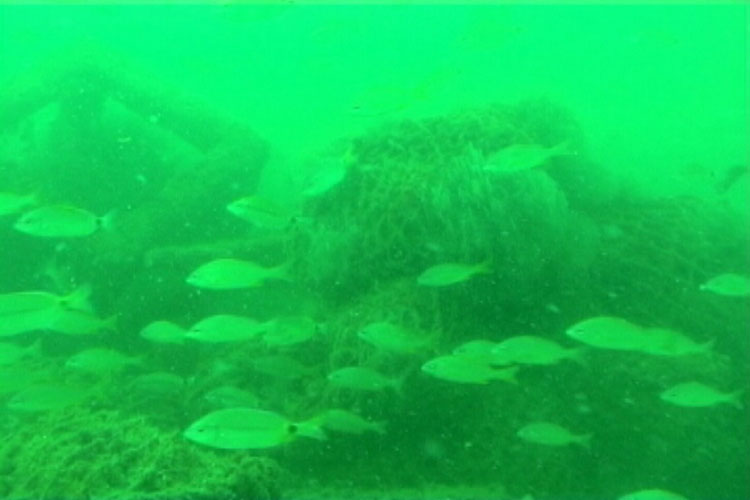
⚫︎ Creation of habitat by placing concrete blocks or natural rocks as artificial reefs for fish on the seabed in limited fishing areas
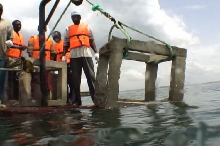
22. Artificial reef installation and the establishment of limited fishing zones
Six artificial reefs made of 3-m concrete blocks were placed in a circumference of 30 m in diameter off Bargny on Petite-Côte and natural rocks weighing 500 kg each were placed 130 m3 inside this area to create a conical mound with a base diameter of 13 m and height of 3 m. After the installation of the reefs, the DPM and CRODT implemented awareness-raising activities among fishers in the area and a management committee composed of representatives of fishers from the five coastal villages (Rufisque, Sendou, Menam, Yène and Bargny) was formed. Following the advice from CRODT, the committee imposed a total ban on fishing in the area where the reefs had been installed to protect the resources and included this measure in the Rufisque departmental decree.
23. Sustainable co-management of resources using artificial reefs
From 2004 to 2005, a model for fisheries resource co-management through the installation of artificial fish reefs was implemented in Yen village. Seventy-five concrete blocks and cages filled with stones weighing 5 metric tons were manufactured, and the local community members themselves installed these artificial fish reefs in the waters off the coast of the village. The village continued to use the artificial fish reefs as a tool for resource management until 2022. Behind the motivation of the community members to continue the resource management activities is that the artificial fish reefs became a symbol beyond their function. The success of the artificial reefs strengthened the unity within the community and promoted community development.
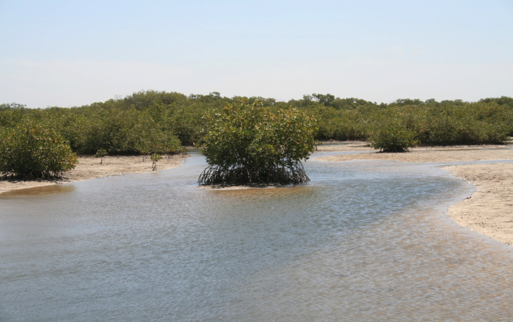
⚫︎ Planting of mangroves to provide a fish nursery area
20. Conservation of nursery areas for fish through mangrove planting
In the village of Djirnda in the Saloum Delta, women began voluntarily planting mangroves around 1990. They felt that the mangroves around their village were deteriorating and that fishing was declining. The mangroves planted by the women grew to 1 to 2-meter tall in the first ten years. The mangrove planting initiated by the village women was supported by a JICA project as they wanted to expand their mangrove forest.
Explain the draft activity plan to the local people and obtain their understanding and cooperation.
The fisheries resource management organisations explain the draft activity plan to the people in the coastal community to gain their understanding and cooperation and recruit collaborators for the activities. With the collaborators, they discuss the draft activity plan with central and local government officials and form a schedule of activities and draft implementation rules. When artificial reefs are established, it is desirable to set the surrounding areas as protected and restricted fishing zones. Therefore, they should obtain the consent of the local people and negotiate with relevant ministries to gain their cooperation. Government agencies consider the adoption of draft activity plans and timetables developed by resource management organisations as part of an order. The organisation also approaches the government and donors to procure the necessary funds and equipment.
21. Considerations for artificial reef installation and mangrove planting
Artificial reefs and mangrove forests with the objective of creating nursery grounds for coastal fish can be established in an MPA because the establishment of the MPA facilitates the achievement of the objective of these measures. When installing artificial reefs or planting mangroves, the following points should be considered:
- ・The installation of artificial reefs on natural reefs that already provide habitat for fish results in the destruction of natural reefs. When artificial reefs are installed, it is necessary to ensure that they have a sandy or muddy bottom.
- ・Shallow water areas are affected by waves more than deep water ones. Artificial reefs should be installed in water depths of 10 m or more.
- ・If artificial reefs are installed in water bodies used by surrounding fishermen as fishing grounds and defined as restricted fishing areas, problems with the fishermen may occur. It is necessary to select an area not used as a fishing ground for the installation of artificial reefs.
- ・When planting mangroves, it is natural to choose a suitable habitat for mangroves. It is advisable to choose an area where mangrove forests were once extensive but have been reduced or lost owing to logging or other reasons.
24. Artificial reef installation to create fish nursery areas in a marine protected area.
In November 2004, the Senegalese government created an MPA at Joal on the Petite-Côte. The aim was to restore or increase stocks in the MPA by protecting spawning fish through banning fishing and regulating fishing methods in the MPA. As the coastal area of Joal has few natural reefs and a monotonous seabed, the Joal CLPA advised that it would be appropriate to install artificial reefs to provide spawning and nursery grounds for fisheries resources in the established MPA.